Introduction
The purpose of this website is to inform people about plate tectonics. I'm doing this website for my Physical Geology portfolio. I will use Google Earth to help support the information about plate tectonics. For example, I will be using Google Earth to do elevation profiles of trenches and ridges, and to show locations of earthquakes and volcanoes.
I will also be talking about the South American Plate at the end. I will apply most of the things that I talk about to the South American Plate. For example, I will talk about South American volcanoes.
I will also be talking about the South American Plate at the end. I will apply most of the things that I talk about to the South American Plate. For example, I will talk about South American volcanoes.
Plate Tectonics
Plate tectonics involves the movement of earth's plates. Earth is separated into 7 major plates, many intermediate -sized plates, and micro plates. The 7 major plates are the North American, South American, African, Pacific, Eurasian, Austrian - Indian, and Antarctic plates. The intermediate - sized plates include the Caribbean, Nazca, and Scotia plates.

Caribbean Plate: The Caribbean Plate is an intermediate - sized plate.
Earth's continents moved due to plate tectonics. Continental margins that have plate boundaries are called active margins. A continental margin is where continental crust and oceanic crust meets. Earthquakes and volcanoes occur at active margins. In contrast, continental margins that lack plate boundaries are called passive margins. Earthquakes and volcanic activity rarely occur at passive margins. The east coast of North America is a great example of a passive margin.

The east coast of North America: There are no plate boundaries on the east coast of North America. This is a passive margin.
Earth's continents were once one continent called Pangaea.

Pangaea: This shows what Pangaea looked like and where certain continents were before Pangaea broke apart.
Overtime, Pangaea started to break up due to plate tectonics. Plate tectonics continued to move the continents to their current positions. Plate tectonics is still moving Earth's continents today. For example, as time passes New York City, New York and London, England are moving farther apart.
Lithosphere
The lithosphere is the rigid outer layer of earth. The lithosphere includes the crust and the upper mantle. There are two types of lithosphere: continental and oceanic.
Continental Lithosphere
Continental lithosphere is about 150 kilometers thick. Continental lithosphere is made of granite and granodiorite. Continental lithosphere is less dense than oceanic lithosphere.

This is a picture of continental lithosphere. The continental lithosphere includes the continental crust and the lithosphere underneath it.
Oceanic Lithosphere
Oceanic lithosphere is about 100 kilometers thick. Oceanic lithosphere is made up of basalt and periodolite. The density of young oceanic lithosphere is less than 3.25 grams per centimeter cubed. The density of old oceanic lithosphere is 3.28 grams per centimeter cubed.

This is a picture of oceanic lithosphere. The oceanic lithosphere includes the oceanic crust and the lithosphere that is underneath it.
Mantle Melting
There are two types of mantle melting. The two types of mantle melting are:
1. Partial melting - Involved with convergent boundaries
2. Decompression melting - Involved with divergent boundaries
Partial melting occurs when pressure drives water out of the ocean sediments on the subducting slab. This causes the rocks in the mantle to melt at temperatures that they wouldn't had if the water wasn't present. A real world example of partial melting is partial melting at a convergent plate boundary.
Decompression melting occurs as rock ascends due to a drop in confining pressure. A real world example of decompression melting is decompression melting at a divergent plate boundary. At a divergent boundary, the starting line for magma is the mantle and the finish line is the ocean floor. Decompression melting pushes the magma upward toward the surface. When the magma reaches the surface, it spills out though a ridge. The magma that is released creates new seafloor.
Plate Boundaries
There are 3 types of plate boundaries. The 3 types of plate boundaries are divergent, convergent, and transform boundaries.
Divergent Boundary
A divergent boundary is a boundary where two plates move away from each other. The picture below shows a representation of a divergent boundary.

When the two plates move apart, magma is released from the mantle though the mid- ocean ridge. New seafloor is created as a result.
Ridge

An elevation profile of the Mid- Atlantic Ridge. The ridge is located at the highest elevation on the elevation profile. Notice how the topography of the ridge is nearly symmetric.
The slower ocean spreading is, the more prominent the ocean ridge is. Some spreading centers don't have much of a ridge.
Age of Seafloor
The youngest seafloor is at the mid-ocean ridge because that is where the magma exits the mantle. The age of the seafloor increases as you get farther away from the mid-ocean ridge.

Mid-Atlantic Ridge (red)- This is a Google earth image showing the age of seafloor at the Mid- Atlantic Ridge.
Earthquakes Involved with Divergent Boundaries
Earthquakes that occur along divergent boundaries occur mainly along normal faults. Normal faults occur where tensional stresses cause Earth's crust to become elongated and stretched.

This is a picture of a normal fault. Notice how one slab is higher than the other slab. This is an example of a dip slip fault, which involves a footwall and a hanging wall. The footwall is the slab on the left and the hanging wall is the slab on the right.
Normal faults generally don't produce large earthquakes. The magnitude of earthquakes along normal faults is usually under a 6. Earthquakes occur near the fault with the largest earthquakes occurring the closest to the fault.
Convergent Boundary
A convergent boundary is a boundary where two plates move together. A convergent boundary is also known as a subduction zone because lithosphere descends (subducts) into mantle. The lithosphere is folded and absorbed into the mantle. Note that ONLY oceanic lithosphere subducts. Continental lithosphere is too buoyant to subduct.
There are three types of convergent boundaries. The two types of convergent boundaries are:
1. Continental- Continental: Two continental plates collide forming a mountain range.
2. Continental - Oceanic: An oceanic plate collide with a continental plate forming a trench and a continental volcanic arc.
3. Oceanic- Oceanic: Two oceanic plates collide forming a trench and a volcanic island arc.
There are three types of convergent boundaries. The two types of convergent boundaries are:
1. Continental- Continental: Two continental plates collide forming a mountain range.
2. Continental - Oceanic: An oceanic plate collide with a continental plate forming a trench and a continental volcanic arc.
3. Oceanic- Oceanic: Two oceanic plates collide forming a trench and a volcanic island arc.


Continental- Oceanic convergence

An ocean trench is created when the ocean lithosphere subducts underneath the continental crust. No trench is formed when two continental plates collide. In the place of the trench a mountain range is formed instead. Note that in the continental-continental picture there is no trench. The picture below shows an elevation profile of a trench.

This is a picture of an elevation profile of a trench off the coast of South America. The plate is subducting where the relatively flat and the mountainous topography meet. The trench is located at the lowest elevation on the elevation profile.
Age of Seafloor
The older oceanic lithosphere is, the greater the angle of subduction. Younger oceanic lithosphere undergoes forced subduction because it is close to the density of continental crust and it is too warm. Forced subduction is when the subducting plate is forced to subduct underneath the overriding plate. The plate subducts at a shallow angle. The subducting plate is just too buoyant to subduct spontaneously. Spontaneous subduction is when old, cold oceanic lithosphere subducts at a steep angle. This creates a deep - ocean trench.
Volcanoes
 Mount Etna: Mount Etna is a volcano in Sicily, Italy.
Most volcanoes are produced by convergent boundaries. A volcano is a vent or fissure in earth's crust though which lava, ash, gases, and rocks erupt. Ash and rocks are examples of pyroclastic materials. Pyroclastic materials are the materials that are projected from volcanoes when they explode. Volcanoes that explode violently release the most pyroclastic materials. Volcanoes that have quiescent eruptions rarely release pyroclastic materials. These volcanoes a small amount of pyroclastic materials if they do release pyroclastic materials.
Volcanoes that have explosive eruptions occasionally produce lava fountains. Those lava fountains are usually harmless, but people are warned to stay away while a volcano is erupting.
Volcanoes that have explosive eruptions are also the most dangerous volcanoes. They are the most dangerous because of the pyroclastic materials released and the explosiveness of the eruption.
Viscosity is a measure of a fluid's resistance to flow. The lower the viscosity, then the more a fluid will flow. If a fluid's viscosity is higher, then it will have a greater resistance to flow. The primary factors that affect viscosity are temperature, gas content, and composition. If the temperature is lower, then the viscosity is higher. Magma with higher viscosity also has higher silica and gas content.
Volcanoes created by Convergent Boundaries
There are 3 types of volcanoes. The 3 types of volcanoes are:
1. Shield Volcano
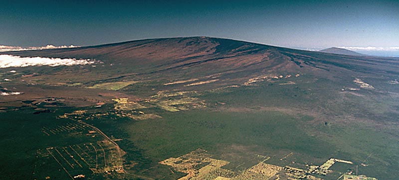
A shield volcano is a broad gently sloping volcano that is formed by fluid basaltic lavas. The shape of a shield volcano resembles a warrior's shield. Most shield volcanoes begin on the ocean floor as seamounts. Some of those sea mounts grow big enough to become volcanic islands. An example is Mauna Loa, which is one of the volcanoes that form the Island of Hawaii. Mauna Loa is the most active volcano in the world, and largest shield volcano in the world. Mauna is highly monitored because of its activity.
1. Shield Volcano
A shield volcano is a broad gently sloping volcano that is formed by fluid basaltic lavas. The shape of a shield volcano resembles a warrior's shield. Most shield volcanoes begin on the ocean floor as seamounts. Some of those sea mounts grow big enough to become volcanic islands. An example is Mauna Loa, which is one of the volcanoes that form the Island of Hawaii. Mauna Loa is the most active volcano in the world, and largest shield volcano in the world. Mauna is highly monitored because of its activity.

Mauna Loa (front) is the largest shield volcano in the world.
Note: Hualālai is the volcano in the background.
Shield volcanoes have quiescent eruptions. This is one of the reasons why shield volcanoes are broad. Another reason why shield volcanoes are broad is because the lava, which is basaltic (mafic), has low viscosity, low silica content, low gas content, and high eruptive temperatures. When lava has low viscosity, it flows better. This leads to a broad volcano.
2. Cinder Cone
A cinder cone (also called scoria cone) is a small volcano that is formed when lava fragments are ejected. The lava fragments that make up a cinder cone are composed of mostly pea - to - walnut size lapilli. Lapilli (cinders) are pyroclastic materials that range from 2 mm to 64 mm. The picture below is a picture of lapilli.
A cinder cone (also called scoria cone) is a small volcano that is formed when lava fragments are ejected. The lava fragments that make up a cinder cone are composed of mostly pea - to - walnut size lapilli. Lapilli (cinders) are pyroclastic materials that range from 2 mm to 64 mm. The picture below is a picture of lapilli.

Lapilli erupted from a volcano
Cinder cone volcanoes are small in size. Cinder cone volcanoes usually range from 300 to 1,200 feet tall. Cinder cone volcanoes usually form over a short period of time. For example, cinder cone volcanoes can form in a few short months, while others take years to form. In addition to a short formation period, cinder cone volcanoes also have a short eruption cycle. For example, a cinder cone volcano usually only erupts once, then it will become extinct. Below is a picture of a cinder cone volcano.

A cinder cone volcano (center) in Fossil Falls, California, USA.
3. Composite Volcano
A composite volcano is a volcano that is made up of pyroclastic material and lava flows. Composite volcanoes are also known as stratovolcanoes. To minimize confusion I will be using the word "composite volcano" from now on. Below is a picture of Mount St. Helens, a composite volcano.
A composite volcano is a volcano that is made up of pyroclastic material and lava flows. Composite volcanoes are also known as stratovolcanoes. To minimize confusion I will be using the word "composite volcano" from now on. Below is a picture of Mount St. Helens, a composite volcano.

Mount St. Helens, located in southwestern Washington State, is an active composite volcano. On May 18, 1980, the summit of Mount St. Helens was removed during a eruption.
Composite volcanoes have explosive eruptions. Composite volcanoes have explosive eruptions because pressure builds up in the magma chamber as gases are dissolved in magma. When the magma reaches the conduits the pressure is released and the gases explode violently. It is like shaking up a can of soda before you open it. When you open the can of soda, the soda explodes everywhere.
Earthquakes involved with Convergent Boundaries
Earthquakes involved with convergent boundaries occur mainly along reverse faults. Reverse faults are created by compressional forces along subduction zones and where two continental plates collide to form a mountain range. The plate boundary between a subducting slab of oceanic lithosphere and the overlaying slab is called a mega thrust fault. Mega thrust faults are capable of producing powerful tsunamis. Mega thrust faults have also produced the majority of Earth's most powerful earthquakes. Some earthquakes involved with mega thrust faults can easily have a magnitude higher than 6. A good example is a 8.4 magnitude earthquake near Peru, South America.

A 8.4 magnitude earthquake occurred near the coast of southern Peru on June 23, 2001.
When dealing with reverse faults the depth at which an earthquake occurs does matter. Since earthquakes occur along the subducting slab, scientists look at earthquake depth.

This is a picture showing the direction of slippage in a normal fault and a reverse (thrust) fault. The reverse fault is on the right.
Earthquakes occur along a reverse fault.
Transform Boundaries
A transform boundary is a boundary where two plates slide pass each other without destroying or creating lithosphere.

This is a picture of a transform fault, also called a transform boundary. The transform boundary is represented by the thin arrows that are point in the opposite direction. We are only looking at the arrows in the middle of the picture.
Earthquakes Involved with Transform Boundaries
Earthquakes involved with transform boundaries occur mainly along strike-slip faults. Strike-slip faults are caused by shear stresses. Strike slip faults exhibits slippage that is mostly horizontal. This horizontal slippage causes two slabs of earth's crust to slide pass each other.

A picture of all of the faults. The picture of a strike-slip fault is the third picture from the top.
An example of a large strike - slip fault is the San Andreas Fault.

San Andreas Fault, California: This picture is taken from the Carrizo Plain in California. The San Andreas Fault is where the ground is disturbed. If you look closely you can see a crack in the ground.
Earthquakes involved in strike-slip faults are usually shallow because they occur within the plates and between the plates. They aren't as strong as earthquakes involved with reverse faults because there is no subduction involved. Strike-slip faults usually produce earthquakes that have a magnitude less than 6, but they can produce earthquakes that have a magnitude greater than 6. A great example of an earthquake that has a magnitude greater than 6 is the San Andreas Fault in California, USA.

This is a Google Earth image of a 7.5 magnitude earthquake that formed near the San Andreas Fault. Note: The San Andreas Fault is a strike - slip boundary.
There is a major difference between strike - slip boundaries and transform boundaries. The difference is that strike - slip boundaries occur on land while transform boundaries occur in the ocean. For example, you can find transform boundaries along the Mid - Atlantic Ridge.
South American Plate
The plate that I'm focusing on is the South American plate. The South American plate has convergent, transform, and divergent plate boundaries.

South American Plate (center) - Key : Yellow - convergent boundary; Blue - transform boundary; White: undefined; Red - Divergent
Introduction of South American Earthquakes And Voclanoes
The South American Plate also has earthquakes and volcanoes. Most of the earthquakes and volcanoes are on the western side of the plate.

This is a picture of the western coast of South America. Most of the volcanoes and earthquakes in South America occur along this convergent boundary. The circle symbols represent earthquakes and the symbols that look like volcanoes are volcanoes.
By looking at the picture of the western coast of South America you will notice that there is a lot of volcanoes and earthquakes on the western coast of South America. The reason why there is a lot of volcanoes and earthquakes on the western coast of South America is there is a convergent boundary on the western part of the South American plate. This is where the Nazca plate is colliding with the South American plate.

Nazca Plate (left) and South American Plate (right) are colliding into each other. The Nazca Plate is subducting underneath the South American Plate.
The number of earthquakes and volcanoes decreases as you head eastward. Volcanoes are almost none existent when you get to the middle of South America.

This is a picture of the middle of South America. Notice that there are no volcanoes and only a few earthquakes.
Volcanoes : South American Plate
Most of the volcanoes on the South American plate are composite volcanoes.

Olca - Paruma is a composite volcano on the northern Chile - Bolivia border in South America. Composite volcanoes are created by convergent boundaries.
South American Earthquakes
Some of the strongest earthquakes in the world occur on the South American plate. For example, On April 1, 2014, a 8.0 magnitude earthquake occurred near Tarapaca, Chile.

A 8.0 magnitude earthquake occurred near Tarapaca, Chile on April 1, 2014. The depth of the earthquake was 10 km (6.21 mi).
The earthquake in Tarapaca killed 6 people and triggered a tsunami with 7 foot waves. The earthquake didn't cause a lot of damage, partly due to the building standards in Chile. The financial loss due to the earthquake is unknown because it is too early to put a price tag on the amount of damage that the earthquake caused.
The strongest earthquake in the world occurred in Chile on May 22,1960. The magnitude of the earthquake was 9.5.

This is a Google Earth image of the strongest earthquake in the world. The 9.5 earthquake occurred in Chile on May 22, 1960. Note: The earthquake in this picture is represented by the red star instead of the circle symbol which also represents an earthquake.
Earthquake Depth
The depth of earthquakes in South America increases as they get farther inland. Earthquake depth is important because it tells you which direction that a plate is subducting in and the angle of subduction.

This is a Google Earth image of a 7.7 magnitude earthquake in Antofagasta, Chile. The depth of the earthquake is 40 km.
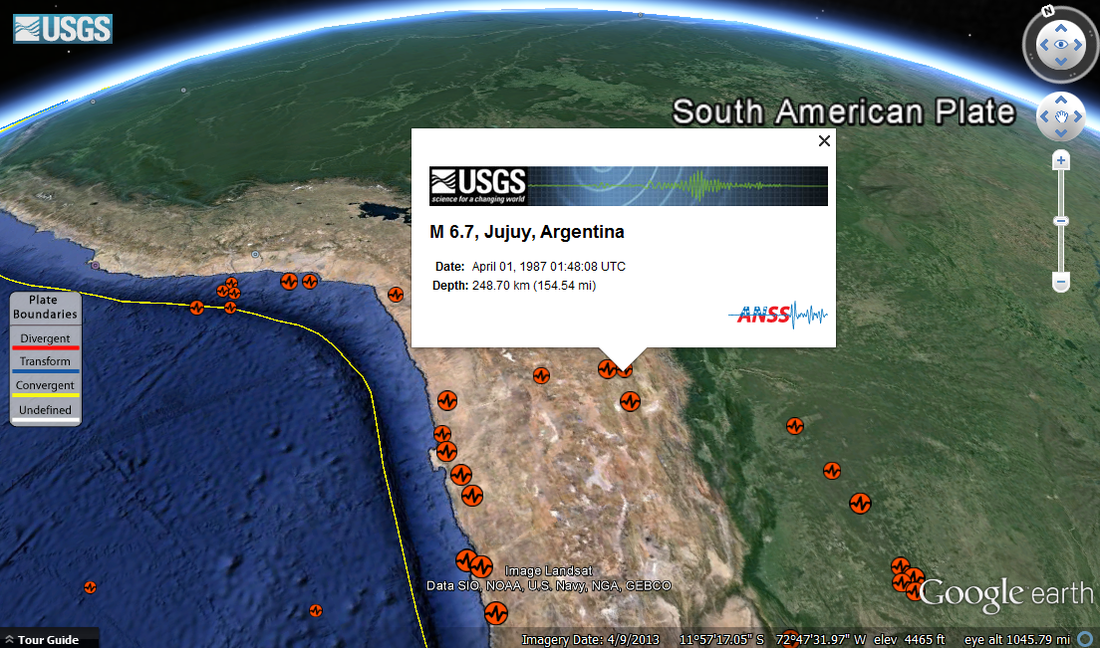
This is a Google Earth image of a 6.6 magnitude earthquake in Jujuy, Argentina. The depth of this earthquake is 248.70 km. Now compare this picture to the picture of the Antofagasta earthquake. Do you see the difference?
South American Earthquakes : Divergent and Transform Boundaries
Some earthquakes on the South American Plate occur along divergent and transform boundaries. Most of the divergent and transform boundaries on the South American Plate are located at the Mid - Atlantic Ridge. The Google Earth images below shows some of the earthquakes that occur along those divergent and transform boundaries.

This is a Google Earth image of a 6.2 magnitude earthquake north of Ascension Island. Note: This earthquake still occurred near the Mid - Atlantic Ridge. This earthquake occurred along a divergent boundary.

This is a Google Earth image of a 7.0 magnitude earthquake along the Mid - Atlantic Ridge. This earthquake occurred along a transform boundary.
South American Plate : Age of Seafloor
The Pacific Ocean and the Atlantic Ocean have different rates of spreading. They also have different seafloor ages. For example, the Pacific Ocean spreads at a fast rate, while the Atlantic Ocean spreads at a slow rate. The Google image below shows the age of sea floor for the Pacific and Atlantic Oceans. Note: The image below only show the age of seafloor for the oceans that surround South America. The Pacific Ocean is on the left, while the Atlantic Ocean is on the right.

This is a Google Earth picture of the East Pacific Rise (left) and the Mid - Atlantic Ridge (right). Compare the red area of the Mid - Atlantic Ridge to the red area of the East Pacific Rise. As you can see, the red area of the East Pacific Rise is wider than the red area of the Mid - Atlantic Ridge. You can infer from this that the East Pacific Rise is spreading faster than the Mid - Atlantic Ridge. The East Pacific Rise is a representation of forced subduction.
Ridge : South American Plate
The Google Earth image below is an elevation profile of the East Pacific Rise.

This is an elevation profile of the East Pacific Rise. The ridge is located at the highest elevation on the elevation profile.
Now compare the elevation profile of the East Pacific Rise with the elevation profile of the Mid- Atlantic Ridge below.

The is an elevation profile of the Mid - Atlantic Ridge. Remember the ridge is located at the highest elevation on the elevation profile.
As you can see, the Mid - Atlantic Ridge's topography is narrower and steeper, while the East Pacific Rise topography is broader and shallower. The East Pacific Rise topography is broader and shallower because it spreads at a much faster rate. The East Pacific Rise doesn't have a prominent ridge because it spreads at a fast rate. The Mid - Atlantic Ridge is able to form a prominent ridge because it spreads at a slow rate.
Trench : South American Plate
The image below is an elevation profile of a trench off the western coast of South America.

This is a Google Earth image of an elevation profile of a trench off the western coast of South America. The trench is located at the lowest elevation on the elevation profile.
Andes Mountain Range
Most of the mountains in the Andes Mountain Range are located on the western coast of South America, while some of the mountains are found in other locations.

The Andes are represented by the brown and rigid topography. Most of the mountains in the Andes are located along the western coast of South America. The Andes are also located along the eastern coast of South America and in north South America.
The Andes at about 4,500 miles long is the longest mountain range in the world. The Andes also includes some of the highest peaks in the world. The Andes spans seven countries in South America. Those countries are Venezuela, Colombia, Ecuador, Peru,
Bolivia, Chile and Argentina.
The tallest mountain in the Andes is Mount Aconcagua in Argentina.
Bolivia, Chile and Argentina.
The tallest mountain in the Andes is Mount Aconcagua in Argentina.

Mount Aconcagua in Argentina: Mount Aconcagua (center) is the tallest mountain in the Andes.
Mount Aconcagua's elevation is 6,962 m (22,841 ft.) above sea level.
The mountains in the Andes Mountain Rage can vary in appearance due to climate. For example, a mountain that is in a place where it snows a lot can have a snowy peak.
The slideshow below shows pictures of some of the mountains that are a part of the Andes.
The slideshow below shows pictures of some of the mountains that are a part of the Andes.
Earth's Size
Throughout earth's history, earth has remained relatively the same size. Convergent boundaries destroy lithosphere. Divergent boundaries do the exact opposite. Divergent boundaries create lithosphere. Although, lithosphere is being destroyed and created, the earth never gets bigger or smaller. The earth never gets bigger or smaller because lithosphere is being created and destroyed at the same time. This prevents earth from changing its size.
Reflection
I had a great experience using Google Earth. At first it was tricky using Google Earth because of the zooming and the dragging. I was like a fish out of water when I first used Google Earth. I got a handle of it after a few tries. I loved learning how to use all the functions in Google Earth, especially the gallery function. I loved the gallery function the most because I loved learning about earthquakes and volcanoes.
I used certain techniques to get the information that I need. I used the path tool in Google Earth to do elevation profiles of certain features like a deep ocean trench. I also used the screen clipping feature in Microsoft Word to get a screenshot of certain overlays. For example, I used the screen clipping feature in Microsoft World to get a screenshot of the information about earthquakes.
I can use this information on this website to learn more about earth. I have always wanted to know more about earth. One of the reasons why I want to learn more about earth is that I want to travel around the world and live in different places. After learning more about California's geology, I wouldn't move there. California has too many earthquakes for me. I would visit California, thought. One of my biggest dreams is to go to Hollywood.
I faced a few challenges while I was doing this website. One of the biggest challenges I faced was finding pictures that I can use. I had to find pictures that were creative commons. That is easier said, than done. I have to overlook many pictures because they were copyrighted. Another challenge I had was finding information about reverse faults. I could only find a little bit of information about reverse faults. Although, I faced some challenges while doing this project, I enjoyed doing it.
I gained numerous strengths while doing this project. One of the strengths that I got from doing this project was I learned how to create a website using Weebly. Before I did this project, I didn't know how to create a website or use Weebly. Using Weebly was so easy to do and fun. I will definitely be using Weebly in the future.
Another strength that I acquired was that I learned how to use Google Earth. Before this project, I didn't know how to use Google Earth that good. Now I know how to use Google Earth. I'm not a pro when it comes to Google Earth, but I know how to use the basic features now.
Sources
Images:
http://en.wikipedia.org/wiki/File:D%C3%B4me_du_Go%C3%BBter_depuis_la_gare_des_glaciers.jpg
http://en.wikipedia.org/wiki/File:Spreading_center_and_strips.png
http://commons.wikimedia.org/wiki/File:Normal-slip_fault.png
http://commons.wikimedia.org/wiki/File:Continental-continental_convergence_Fig21contcont.gif
http://commons.wikimedia.org/wiki/File:Active_Margin.svg
http://commons.wikimedia.org/wiki/File:Volcano_Etna_Italy_Sicily_-_Creative_Commons_by_gnuckx_(3491530173).jpg
http://upload.wikimedia.org/wikipedia/commons/0/0c/Oceanic-oceanic_convergence_Fig21oceanocean.gif
http://upload.wikimedia.org/wikipedia/commons/e/e0/Mauna_Loa_Volcano.jpg
http://commons.wikimedia.org/wiki/File:Fogo-Pico_Pequeno-Lapilli_(6).JPG
http://fr.fotopedia.com/items/flickr-1815769187
http://en.wikipedia.org/wiki/File:MSH82_lahar_from_march_82_eruption_03-21-82.jpg
http://en.wikipedia.org/wiki/File:Nor_rev.png
http://en.wikipedia.org/wiki/File:Transform_fault.jpg
http://commons.wikimedia.org/wiki/File:Faults6.png
http://en.wikipedia.org/wiki/File:Kluft-photo-Carrizo-Plain-Nov-2007-Img_0327.jpg
http://en.wikipedia.org/wiki/File:Monte_Aconcagua.jpg
Slideshow
Picture 1: http://en.wikipedia.org/wiki/File:Aerial_photo_of_the_Andes.jpg
Picture 2: http://en.wikipedia.org/wiki/File:Fitz_Roy_Chalten_Argentina_Todor_Bozhinov_2013.jpg
Picture 3: http://en.wikipedia.org/wiki/File:Andes_bolivianos.jpg
Picture 4: http://en.wikipedia.org/wiki/File:Huayna_Potosi2.jpg
Picture 5: http://commons.wikimedia.org/wiki/File:ILLIMANI.jpg
Picture 6: http://en.wikipedia.org/wiki/File:Santiago_Skyline.jpg
Picture 7: http://en.wikipedia.org/wiki/File:Nevadohuandoy.jpg
Picture 8: http://commons.wikimedia.org/wiki/File:The_Andes_(5842694105).jpg
Picture 9: http://commons.wikimedia.org/wiki/File:Andes_Mountains_South_America_Photograph_020.JPG
Picture 10: http://commons.wikimedia.org/wiki/File:Chacraraju.jpg
Picture 11: http://en.wikipedia.org/wiki/File:Salcantay_Stevage.jpg
Picture 12: http://commons.wikimedia.org/wiki/File:Snows_of_the_Andes_(7914098320).jpg
Picture 13: http://en.wikipedia.org/wiki/File:PicoBolivar3.jpg
Google Earth:
1. Age of- the - Ocean Floors
KML link:
Age-of-Ocean-Floors.kmz
Website:
http://nachon.free.fr/GE/Welcome.html
2. Earth's Tectonic Plates
KML link:
Earth's Tectonic Plates - USGS
Website:
http://earthquake.usgs.gov/regional/nca/virtualtour/global.php
3. Historic Earthquakes
KML link:
http://earthquake.usgs.gov/earthquakes/world/events/1960_05_22.kml
Website:
http://earthquake.usgs.gov/earthquakes/world/events/1960_05_22.php
References
Tarbuck, Edward J., Fredrick K. Lutgens and Dennis Tasa. Earth: An Introduction to
Physical Geology. Ed. Andrew Dunaway, Crissy Dudonis and Sean Hale. 11th.
Pearson Education Inc.,
2005.
Bagley, Mary. Mount St. Helens Eruption: Facts& Information. 28 February 2013. TechMedia Network.
13 March 2014 < http://www.livescience.com/27553-mount-st-helens-eruption.html>.
Bagley, Mary. Volcano Facts and Types of Volcanoes. 20 February 2013. TechMedia
Network. 14 March 2014
<http://www.livescience.com/27295-volcanoes.html>.
USGS. Mauna Loa Earth's Largest Volcano. 2 February 2006. 14 March 2014
<http://hvo.wr.usgs.gov/maunaloa/>.
King, Hobart. Transform Plate Boundaries. n.d. Geology.com. 16 March 2014
<http://geology.com/nsta/transform-plate-boundaries.shtml>.
Zimmermann, Kim Ann. Andes: World’s Longest
Mountain Range. 13 March 2013. TechMedia Network. Web. 24 March 2014.
<http://www.livescience.com/27897-andes-mountains.html>.
Echeverria, Rodrigo. 3 December 2003. Web. 26 March
2014. <http://www.andeshandbook.org/cerro.asp?codigo=112>.
Huandoy, Peru. 1 November 2004. Web. 27 March 2014.
< http://www.peakbagger.com/peak.aspx?pid=8461>.
C.A., Arassari Trek. Pico Bolivar - 5.007m. n.d. Arassari Trek C.A. Web. 30
March 2014. <http://arassari.com/3-trek1.htm>.
Interactive Outdoors, Inc. Huayna Potosi. n.d. Interactive Outdoors Inc. Web. 30 March 2014.
<http://www.peakware.com/peaks.html?pk=113>.
peakbagger.com. Chacraraju, Peru. 01 November 2004. Web.
30 March 2014. <http://www.peakbagger.com/peak.aspx?pid=8460>.
peakbagger.com. Salcantay, Peru. 1 November 2004. Web. 30 March 2014.
<http://www.peakbagger.com/peak.aspx?pid=8487>. SummitPost.org. Fitzroy. n.d. Web. 31 March 2014. <http://www.summitpost.org/fitzroy/153622>.
Esposito, Anthony and Rosalba O'Brien. Chile assesses damage after massive quake, tsunami. 2 April 2014. Web. 6 April 2014.
<http://www.reuters.com/article/2014/04/02/us-chile-earthquake-idUSBREA3101G20140402>.

.jpg)
.JPG)
.jpg)
.jpg)